Kittatinny Coalition Support
The Kittatinny Coalition is an alliance of organizations, agencies, and academic institutions working with municipal officials and private landowners to conserve the natural, scenic, cultural, and aesthetic resources of the Kittatinny Ridge and Corridor. Shippensburg University is an active member, and has partnered to conduct GIS and demographic analyses and user surveys to support conservation and communication efforts along the Kittatinny Ridge.
Kittatinny Ridge Recognition and Identification Survey
The Appalachian Trail Conservancy, through a grant from the Department of Conservation and Natural Resources (DCNR), partnered with the CLUS and Kittatinny Coalition to conduct the Kittatinny Ridge Recognition and Identification Survey in 2019. The purpose of the survey was to create a better understanding of how residents and tourists use the Kittatinny Ridge and surrounding area for outdoor recreation, what they know about it, how people identify with the Ridge, what could improve their experiences, and what economic and conservation opportunities they see as priorities along the Ridge.
The Kittatinny Coalition and other conservation groups and state agencies may use the survey responses to consider and develop improved recreation opportunities, enhanced natural resource protection efforts, and a communication strategy that helps boost appreciation for, and fill knowledge gaps about, the Ridge. Learn more in the survey summary.


GIS Support Services
With funding from Audubon Pennsylvania through the Department of Conservation and Natural Resources, the CLUS conducted GIS analyses from 2017-2020 for the Kittatinny Ridge focused on three goals:
Create and maintain GIS datasets
Create and maintain a series of GIS data sets to support research and conservation activities. The current GIS data list GIS can be found here, and geodatabases will be available through the Pennsylvania Spatial Data Access (PASDA) portal. Search for the keyword “Kittatinny Ridge” or by data provider for “Center for Land Use and Sustainability.”
Calculate baseline landscape metrics
Update parcel prioritization analysis
ATC Cluster Demographics
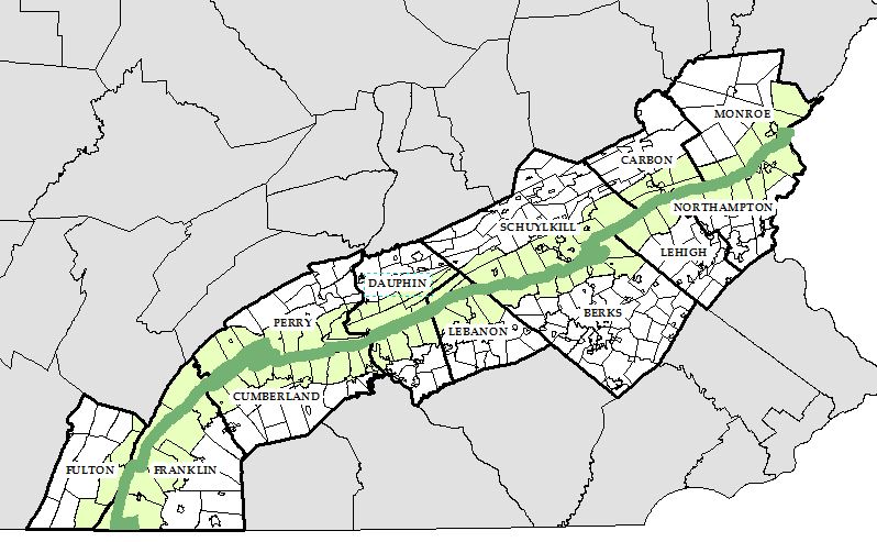
The Appalachian Trail (A.T.) is the world’s longest hiking only foot trail, stretching from Georgia to Maine. The full extent of the trail traverses through lands owned and managed by federal agencies, state agencies, local municipalities, and non-profit groups. Much of the A.T. corridor includes lands that are vital for the protection of natural resources and watershed quality. The Appalachian Trail Conservancy (ATC), a non-profit group whose mission is to preserve and manage the trail, seeks to educate and engage community leaders and residents in implementation of conservation practices that protect the Appalachian Trail Corridor.
The William Penn Foundation sponsors the Delaware Watershed Initiative (DRWI), which works across four states to protect the source of clean water for the Delaware River. Both groups’ missions are served by conservation strategies on lands proximal to the A.T. corridor and within the Delaware Watershed.

With financial support through William Penn Foundation, the ATC seeks to develop an outreach campaign to facilitate conservation practices that protect forest cover and riparian buffers along the A.T. corridor. The ATC’s outreach model will focus on 28 municipalities within the following four DRWI clusters: Poconos and Kittatinny, Upper New Jersey Highlands, Upper Lehigh, and Middle Schuylkill. In support of this work, in 2019 the CLUS conducted a demographic analysis of the municipalities and counties that intersect the Appalachian Trail along the Kittatinny Ridge.
Read the Final Report or view the Story Map to learn more.
Land Cover Dynamics Along the Kittatinny Ridge
In 2017, two CLUS students developed a storymap to analyze land cover dynamics along the Kittatinny Ridge. This resource will be used to guide management decisions, facilitate community outreach and education, and as a baseline for ongoing preservation efforts. The interactive map features background information about the coalition as well as long and short term land cover trends. Land cover dynamics were assessed at the municipal scale to better understand how the ridge is changing over time. Explore the interactive map here: https://arcg.is/Sf9qS.

Affiliate Scholars

Alfonso Yáñez Morillo
Research Analyst, Center for Land Use and Sustainability

Claire Jantz, Ph.D. – Past Director
Deputy Secretary

Jackie Rosenberger
Undergraduate Student Fellow

Jonathon Chester
Undergraduate Student Fellow

Patricia Newdeck
Graduate Student Fellow

Sarah Thompson
CLUS Graduate Student Fellow

Troy Alleman
Graduate Student Fellow
